
GRAMDRISHTI
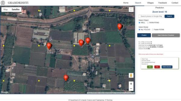
Gramdrishti is a software for detecting and annotating objects from satellite images in rural area. Right now it can detect wells only. But the types of objects will be extended in future.
The motivation behind well detection was to automate the process of well census performed by the Govt. of India in every five year. Well census is very crucial for detecting the groundwater exploitation in a certain region. Every year several states of India like Maharashtra, Madhya Pradesh, Karnataka suffer from a huge amount of water crisis during summers. The water crisis is inversely related to the amount of groundwater present in that state. The amount of wells present in a region directly affects the amount of groundwater in that region which results in the colossal water crisis in the rural areas of these states. Generally, the farmers are also supposed to register their land and well information to their nearest revenue department office which will in turn avail many governmental schemes like drip irrigation subsidy, etc. But this process generally gets delayed and incomplete due to complex ownership issues ofthe land which ultimately affects both the farmers and the government. It results in a deficiency of data on groundwater usage and preservation. For this reason, the Central Groundwater Board conducts a census every five years on the number of wells and other water resources to estimate the irrigation potential of different regions. But this surveying process is prolonged and not cost-effective. However, by automating this process we can save several work hours of government officials and economic value. This will also be apromising step in building an e-governance framework for our country.
The process of automating the well detection generally falls in the area of computer vision and applied machine learning. We have used YOLO and its different version for object Detection. We can overlay thesewell locations on the cadastral maps with land ownership information which will enableus to detect the well ownership by land.
Dug Wells are hollow circular objects and hence are annotated using shape as circle. The dataset consists of total 1011 images consisting of 1614 wells from 34 districts of Maharashtra. Each image size is of 640x640 pixels and is extracted from Google Static Maps taken at a zoom level of 19 which is highest minimum zoom level found across our target area and covers approximately one hectare of land. This dataset can be used for image classification, object detection and instance segmentation tasks.
Farm Ponds are found to be in different sizes, shapes and types. The annotations are done using polygons. Since both dry and wet farm ponds can be lined or unlined, we get four classes of objects:-Dry Farm Pond - Lined and Unlined, Wet Farm Fond - Lined and Unlined. The dataset consists of 1018 images consisting of 370 instances of each type totaling 1480 farm ponds from 34 districts of Maharashtra. Each image size is of 640x640 pixels.
Check Dams are small barriers built across the direction of water flow on shallow rivers and streams for the purpose of water harvesting. Based on how these structures look from satellite images we have divided them into Wall Based CheckDam and Gate Based CheckDam. The dataset consists of 1037 images consisting of 562 instances of Wall Based CheckDam and 520 instances of Gate Based CheckDam totaling 1080 checkdams from 34 districts of Maharashtra. Each image size is of 640x640 pixels.
A total of 694 images of size 1024 x 768 pixels at zoom level 18 with a very high resolution (up to 1 meter) were collected from Google Earth images. The region of Indian state of Maharashtra was chosen for the dataset. The villages collected have timestamps in months of Jan-April and the minimum year difference is 2 years and the maximum year difference is 9 years, oldest being 2007 and latest being 2021. The types of farm ponds being covered in the dataset are Wet Farm Pond - Lined, Wet Farm Pond - Unlined, Dry Farm Pond - Lined, Dry Farm Pond - Unlined. The change classes are mainly - Farm Pond Constructed, Farm Pond Demolished, Farm Pond Dried and Farm Pond Wetted. Most of the changes are from the farm pond constructed class showing that there is an increase in farm pond construction across villages in Maharashtra in past 8-9 years.